Joy Singarayer
![]()
Main research projects (funded and unfunded):
![]() Drivers of late
Quaternary African humid/arid phases (with Aidan Farrow and Paul Valdes)
Drivers of late
Quaternary African humid/arid phases (with Aidan Farrow and Paul Valdes)
![]() Bio-geoengineering crops for global warming mitigation (with
Andy Ridgwell and Alistair Hetherington)
Bio-geoengineering crops for global warming mitigation (with
Andy Ridgwell and Alistair Hetherington)
![]() Glacial
cycle climate variability (with Paul Valdes)
Glacial
cycle climate variability (with Paul Valdes)
![]() Patagonian
Ice-sheet impacts during the deglaciation (with
Neil Glasser, Geoff Duller and Krister
Jansson)
Patagonian
Ice-sheet impacts during the deglaciation (with
Neil Glasser, Geoff Duller and Krister
Jansson)
![]() Understanding
radiocarbon gradients (with Michelle Felton, David Richards, Andy Ridgwell and Paul Valdes)
Understanding
radiocarbon gradients (with Michelle Felton, David Richards, Andy Ridgwell and Paul Valdes)
![]() The role of sea-ice in
Arctic climate variability (COAPEC, with Jonathan Bamber
and Paul Valdes)
The role of sea-ice in
Arctic climate variability (COAPEC, with Jonathan Bamber
and Paul Valdes)
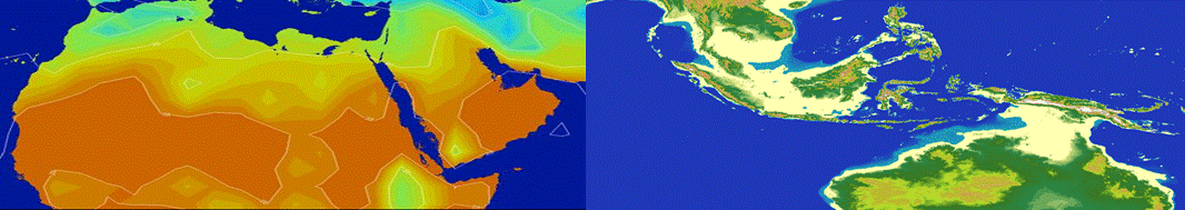
Drivers of late Quaternary African humid/arid phases
Palaeoclimate records from
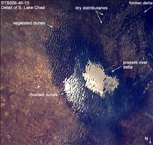
Figure 1. Evidence that
The
reason for the changes between wet and dry phases over the late Quaternary has
been the subject of much interest. Previous work has shown that wetter
conditions in Northern Africa during early Holocene may have been due to
changes in the Earth's orbital parameters, resulting in an increased
seasonality, and increase in precipitation over the region. It has been
suggested that there is antiphasing between the
Southern and Northern hemispheres timing of maximum surface wet conditions.
This has also been used to infer that changes in solar insolation are the key
forcing mechanism. However, recent work has found that the patterns are much
more complex, particularly in the southern and eastern African palaeorecords. Several records show significant
correlations with the timing of high latitude Heinrich iceberg discharges,
which cause rapid changes in large-scale ocean circulation. Preliminary studies
with a climate model have demonstrated the possibility of high latitude forcing
of African environments on millennial time-scales.
There
are also important climatic feedbacks when extensive lakes and wetlands are
present. The presence of substantial surface water, in the form of lakes and
wetlands, impacts on regional climate through changing the surface albedo,
surface energy and moisture budgets, and modified heat capacity. Previous
studies have confirmed the importance of surface water in modelling African palaeoclimates, the North African monsoon has been found to
be particularly sensitive to land surface changes. Key unresolved questions
concern the current lack of consensus on the forcing mechanisms of arid/humid
transitions, partly because the timing is difficult to ascertain from palaeorecords, and partly that while modelling studies have
demonstrated the importance of including surface water changes, detailed
examination of mechanisms of transient changes and feedbacks have yet to be
undertaken. This NERC funded PhD project seeks to examine these mechanisms using
the Hadley Centre climate model and interactive vegetation and surface
hydrology models. [started October 2008]
Bio-geoengineering crops for global warming mitigation
Geoengineering is the
manipulation of either the Earth's albedo or atmospheric composition to
mitigate global warming. This project involves the investigation of the idea of
increasing the albedo of agricultural crops via choosing species with higher
natural albedos or changing leaf glaucousness.
Initial investigations have involved the assessment of this concept with the
Hadley Centre ocean-atmosphere-vegetation model in which the albedo of C3 and
C4 plants in agriculatural regions has been increased
(See publication list: Ridgwell et al., 2009 and
Singarayer et al., 2010). Further examination will include physical assessment of
the range of albedos or crop sub-species at leaf and
canopy level.
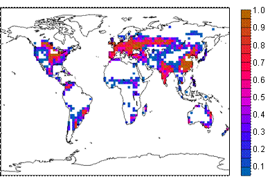
Figure 2. Fraction of
HadCM3 model grid cells designated as agricultural land, in which C3 and C4
plant functional type albedo is increased.
Glacial cycle climate variability
This
is an ongoing project which was initially funded by the BBC as part of the
series, The Incredible Human Journey. We have run several large model
experiments to reconstruct the last glacial cycle (120kyr to present). These
are currently being used to investigate mechanisms and timings of orbital scale
changes in the Earth system. Specific projects underway are glacial cycle
changes in Polar Regions (Singarayer and Valdes, 2010), wetland and methane
emissions changes, influences on the ITCZ and monsoons, and expression of
millennial vs orbital scale changes in the
hydrological cycle over
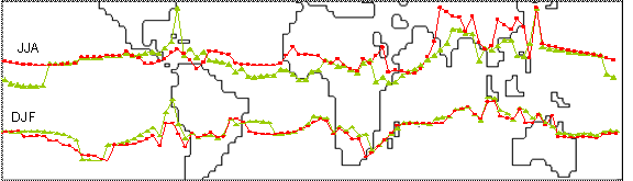
Figure 3.
Average HadCM3 seasonal ITCZ position at maximum (red) and
minimum (green) boreal summer insolation, mostly influenced by orbital
precession.
Patagonian Ice-sheet impacts during the deglaciation
Research
grants provided to Glasser (NERC) and Jansson (Swedish Research Council). The aims are to
reconstruct the evolution of the southern
Understanding radiocarbon gradients
Variations
in the ratio of carbon-14 to carbon-12 isotopes (∆14C) have the potential
to provide valuable information concerning millennial-scale climate changes,
carbon cycle, solar activity and geomagnetic strength. However, deconvolving these different factors is difficult from data
alone, even when using complementary records. Modelling ∆14C has the
potential to play a crucial role in extracting maximum understanding from the isotope
record. We are using a recently developed intermediate-complexity 3D Earth
System Model (Grid Enabled Integrated Earth system model, GENIE) to
quantitatively examine the causes of ∆14C variability, and hence improve
our understanding of the mechanisms of natural Earth system change. The model
is unique because of its fully dynamic representation of the spatial and
temporal patterns of long-term (multi-millennial) Earth system variability, and
by including all major components of the Earth system. It includes a fully
dynamic atmosphere and ocean, a dynamic terrestrial carbon cycle, and a
detailed representation of the ocean carbon cycle, and is capable of multi-millennial
simulations. We are using this model to quantitatively investigate the possible
causes of variations in ∆14C during the last 50,000 years and combine the
modelling studies with data in order to advance our understanding of Earth
System History. One example is the approach of data-model comparisons of radiocarbon
distribution during the Younger Dryas to investigate
the cause of the increase in atmospheric radiocarbon concentrations (Singarayer
et al., GRL, 2008).
The role of sea-ice in Arctic climate variability
This
was a NERC COAPEC
(Coupled Ocean-Atmosphere Processes for European Climate) theme funded project
to investigate the role of Arctic sea-ice in European and
![]()


![]()